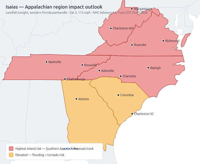

Atlanta: You are on the Saturday tornado-risk line and under a flooding-rain threat. Isaias makes landfall on the Gulf Coast tonight and moves inland through Alabama into the Tennessee Valley, putting north and central Georgia in the impact zone Saturday.
(Note: this is the 2026 Isaias — not the 2020 storm of the same name.)
What to expect in metro Atlanta
- Saturday: Level 2 tornado risk over metro Atlanta. Don’t let “Level 2” fool you — these are quick, rain-hidden spin-ups, often overnight. Warnings may come with only minutes of lead time, so charge your phone and know your interior room now.
- 2–5 inches of rain area-wide, with higher totals possible; localized flash flooding.
- Gusty winds → scattered power outages.
- Impacts continue into Sunday as the system pulls away northeast.
If you’re running or playing a game this weekend
- Check before you travel. Many local game stores will adjust hours or close — call or check their socials first.
- Saturday games are the most at-risk. Consider postponing to Sunday afternoon or next weekend.
- If you do play, avoid low-lying routes and flooded intersections; Atlanta’s flash floods are fast and deceptive.
- Organizers: update your Warhorn/event listing and notify your players directly. Cancel early — nobody’s mad about a cancelled game.
- Lost your session? No penalty for rescheduling. Table continuity matters less than safety.
What the alerts mean
- A Watch means get ready. Conditions are possible, usually hours out.
- A Warning means act now. It’s happening or imminent — take shelter. This applies to tornadoes, flash floods, and severe thunderstorms alike.
- Never drive through flooded roads. “Turn around, don’t drown.”
Prep now
- Charge phones and power banks
- Keep a flashlight and water on hand
- Top off the gas tank
- Bookmark GDOT travel info: https://511ga.org
Weather terms, decoded
- NHC / NOAA — National Hurricane Center / National Oceanic and Atmospheric Administration; the federal agencies issuing storm forecasts.
- NWS — National Weather Service; your local office (Peachtree City, for Atlanta) issues the watches and warnings for your county.
- Category 1–5 (Saffir–Simpson) — hurricane strength by wind speed. Cat 3 and above is a “major” hurricane. Isaias is Cat 3.
- Tornado risk level 1–5 — from the Storm Prediction Center. 1 = isolated, 5 = outbreak. Level 2 (“Slight”) = scattered severe storms; still dangerous, especially at night.
- Tornado Watch vs. Warning — Watch = get ready. Warning = act now, take shelter.
- Flash Flood Watch vs. Warning — Watch = flooding possible. Warning = flooding happening or imminent.
- Storm surge — ocean water pushed inland by the storm.
- Turn around, don’t drown — the standing rule for flooded roads.
Official resources
- NOAA Isaias hub: https://www.noaa.gov/isaias
- National Hurricane Center: https://www.nhc.noaa.gov/
- NWS Peachtree City (Atlanta): https://www.weather.gov/ffc
- Prep checklist: https://www.ready.gov/hurricanes
Risk levels are probabilities, not guarantees. A Watch means get ready; a Warning means act now.
Stay dry, stay safe, and game again next week if you have to.